FORECAST HIGHLIGHTS
-
GOOD RAINFALL: The highest totals were west of San Antonio overnight
-
STORMS TONIGHT: Mostly between midnight and 12pm
-
SEVERE POSSIBLE: Hail, gusty winds, heavy rain with stronger storms
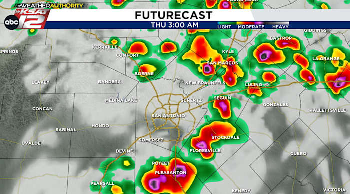
FORECAST
STORMS TONIGHT
Scattered to widespread storms are most likely from midnight tonight to noon tomorrow. Most of the action should be from Bexar County (and surrounding counties) eastward. Places west of a line from Kerrville to Hondo to Devine have minimal storm chances.
The morning commute is likely to be impacted by passing storms, and at any point, storms could become strong/severe with high winds and large hail.
It was a loud, rainy overnight. The storms were strongest west of San Antonio, where a gust of 66 mph were recorded in Del Rio, and damage was reported in Sabinal. For San Antonio, it was just a steady rain. Most rainfall totals across the city stayed below 1″.
24-HOUR RAINFALL TOTALS
THURSDAY THROUGH SUNDAY
Thursday afternoon looks quiet and the upper-low, which has been making the recent storms, will begin to slowly move away from us. That means rain chances will come down. Still, we’ll have a shot at isolated storms through the weekend. The flow is such that we’ll also need to keep an eye on any clusters of storms that make a run at San Antonio.
QUICK WEATHER LINKS
Copyright 2025 by KSAT – All rights reserved.
Leave a Reply