ORLANDO, Fla. – A potential tropical disturbance headed towards the Southeastern United States is likely to bring heavy rains to the state over the Fourth of July weekend, according to the FOX 35 Storm Team and the National Hurricane Center (NHC).
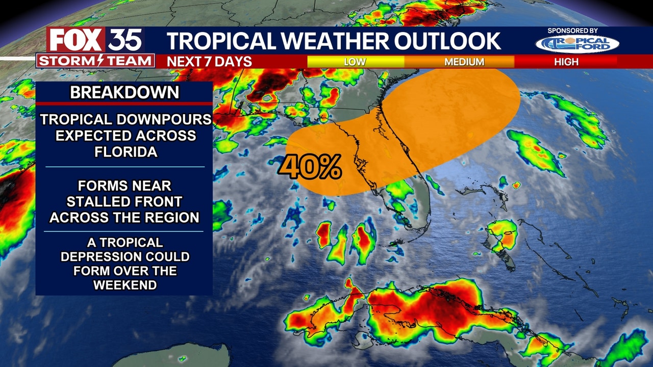
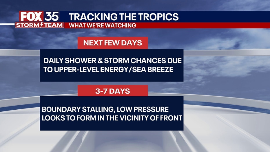
The NHC said in its latest update that a frontal boundary is expected to stall and weaken off the U.S. Gulf Coast this week. An area of low pressure could then develop and potentially bring subtropical or tropical, the NHC said. As of Wednesday morning, the chances of development in the next seven days had increased to 40%, but the chances of development within the next 48 hours were near 0%.
What can we expect in Florida?
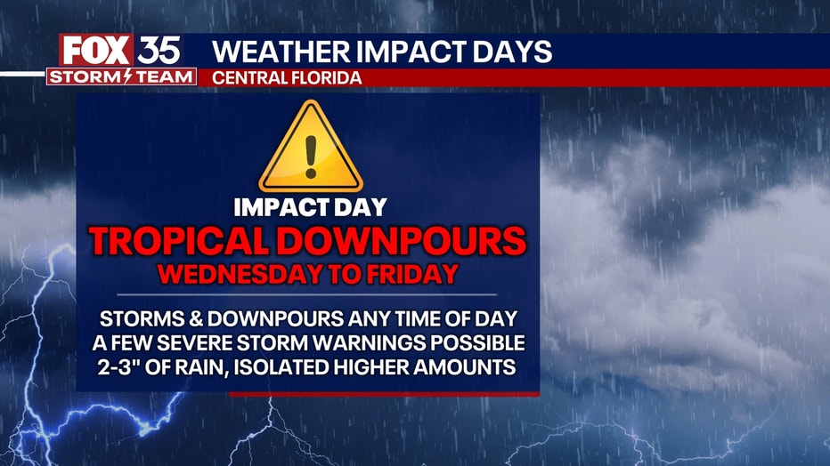
The FOX 35 Storm Team said this sytem will likely bring daily storms, showers and downpours to the state. Some may be severe with strong winds and large hail.
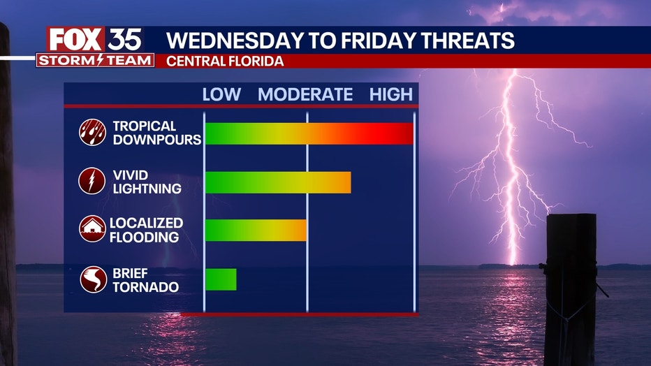
With plenty of tropical moisture in place, a lot of rain will fall over a short period of time.
CLICK TO DOWNLOAD THE FOX LOCAL APP
The best chances of rain will be during the afternoon, with the peak heating of the day starting Wednesday and lasting into at least Saturday.
So far, areas along the Florida Gulf coast, specifically near Tampa through the Big Bend region, will be where the highest rainfall totals will be. This is where more than 6 inches of rain could fall.

Florida Fourth of July Forecast
The FOX 35 Storm Team says this unsettled weather pattern will heighten the risk of flooding across Central Florida, especially during peak holiday travel and events.
Residents and visitors are encouraged to monitor forecasts closely as the situation evolves.
Fourth of July travel at Orlando International Airport (MCO)
More than 1.4 million people are expected to fly into or out of Orlando International Airport (MCO) this week ahead of the Fourth of July holiday.
Here are the top five busiest days expected at MCO:
- Sunday, July 6 – 175,559 (arrivals & departures)
- Sunday, June 29 – 174,053
- Monday, July 7 – 167,536
- Monday, June 30 – 166,746
- Saturday, July 5 – 166,508
Unusually quiet hurricane season
So far, the 2025 Atlantic hurricane season has been unusually quiet, with the basin’s Accumulated Cyclone Energy (ACE), sitting at a meager 0.2 units. ACE is a metric used by forecasters to quantify the strength and duration of tropical cyclones, with greater values indicating stronger, longer-lasting systems.
SIGN-UP FOR FOX 35’S BREAKING NEWS, DAILY NEWS NEWSLETTERS
According to data compiled by Colorado State University, the 2025 ACE value is more than 90% below average for the Atlantic Ocean, Caribbean Sea and Gulf.
The peak of hurricane season typically comes in mid-September, so while activity is low now, forecasters caution that this is not an indicator of the full season’s potential.

2025 Atlantic hurricane season: What to expect
The 2024 Atlantic hurricane season ended with 18 storms, 11 tropical storms, and 5 hurricanes – 3 of which made landfall in Florida (2 as major hurricanes). The 2025 hurricane season is a few months away (Feb. 21 marks 100 days until June 1, the official start of the hurricane season).
FOX 35 Storm Tracker Radar and Live Weather Cameras
Track live when storms move across your area using the FOX 35 Storm Tracker Radar below. You can also watch as heavy rain moves across Central Florida on our Live Weather Cameras’ page here.
More radar maps from FOX 35 Storm Tracker Radar
The Source: This story was written based on information shared by the National Hurricane Center (NHC) and FOX 35 Storm Team on July 2, 2025.
Leave a Reply